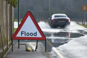
When we think of floods, we typically think of overflowing rivers and rising sea levels. These types of floods are common, but only for people who naturally live close to a river or the sea. Those that live in more urban areas, such as cities, typically don’t consider flooding as a problem. Yet one type of flooding can actually affect those in more built-up areas far worse – surface water flooding.
What is surface water flooding?
Have you ever walked home from work after a particularly rainy day to find a road completely covered in rainwater? Surface water flooding is this but on a much larger scale. When there is too much rain for drains to handle, it ends up on our roads and streets. While this can damage a cities infrastructure, the surface water can then end up damaging homes and businesses much like a more traditional flood can.
The key difference is that if the rain is bad enough, surface water flooding can affect anywhere, meaning areas that aren’t necessarily prepared or used to flooding can be hit without warning. The UK government reported back in October that over 3 million properties in England are at risk of surface water flooding. That’s higher than those at risk from rivers and the sea (2.7 million).
Urban areas with high-density housing and lots of concrete are actually the most susceptible to surface water flooding. These areas generally lack large green areas which are good for absorbing rainwater. When rain hits pavements, parking spaces, and paved drives, the water isn’t absorbed. Most of it may head to drains, but when there’s too much, they can’t cope and you get surface water floods.
A brief history of surface water flooding
So just how common are surface water floods? Here in the UK, they aren’t as common as more traditional floods, but they do still occur. In recent times, the floods of 2013 left 13 people dead, 44,600 homes flooded and £3bn in damage.
It’s not just the UK though. Last month, the flash floods that hit Majorica that killed two British nationals were also due to surface water flooding.
Its unpredictability is what makes surface water flooding so dangerous. A coast flood can typically be predicted 2-5 days before it arrives. A river flood can be usually be dedicated within 12-48 hours. When it comes to surface water flooding, predicting its arrival can prove immensely difficult. We may be able to predict when rain is imminent, but where, how long and what the effects will be are questions far more difficult to answer before it arrives.
So what can be done?
That’s not to say governments aren’t doing their part to help prevent and protect communities from surface water floods. In the UK, following the Pitt review, the government created the Flood and Water Management Act.
This particular act helped set out the roles and responsibilities of particular groups in regards to flood risks. In particular, it created what is known as Lead Local Flood Authorities – particular councils that are responsible for managing flood risk in their area.
From this, flood warning services have been created, meaning over 1.4 million people can receive warnings of floods to their mobile phones. There has also been an investment into flood barriers, pumps, incident response vehicles and staff. An estimated £2.6 billion will be spent on flood prevention by 2021.
But it’s also about putting power into ordinary people’s hands. One such way is through the creation of Risk of Flooding from Surface Water maps. Anyone can access them online to check whether their home or area is at risk, measured as a very low, low, medium or high risk.

Helping predict a flood
Predicting when a surface water flood will occur is difficult – but it isn’t impossible. Measuring water levels in key areas, such as in drains and basements can help alert you to when water levels are rising, allowing you to plan ahead to help limit the potential damage.
Doing so typically requires what is known as an Early Flood Warning System. This small device can be installed in key areas to monitor water levels remotely. What’s more, anyone with the device’s number can text it to receive a reply with the water level and its rate of change.
Stansted Mountfitchet, a small village in Essex is an area that is at a high risk of flooding. They recently installed early flood warning devices to better prepare the community and give them more time to react.
Interested in purchasing an early flood warning system for yourself or for your community? Check out the Leveline-EWS here, or alternatively get in contact with us to find out more.
