What is water dredging?
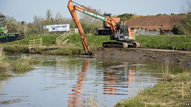
Water dredging is the process of removing silt, clay and small particles of rock from the bed and sides of a waterbody. Over time silt and other sediment builds up, which reduces the capacity of the river channel.
The dredging procedure usually involves the use of an excavator or vacuum pump, which will be stationed on a barge or on the river bank. The dredging equipment clears the bottom and sides of the water body, enabling waterways to flow freely. Dredging is often used to keep waterways navigable.
Dredging for flood prevention?
Dredging can be considered essential for river maintenance and flood prevention. Widening and deepening a river channel allows it to carry more water so reducing the risk of the river bursting its banks. However, altering the channel can increase the risk of flooding downstream because the water is carried there more quickly.
The winter of 2013/14 was particularly wet and many areas suffered substantial flooding for prolonged periods of time. One of the worst affected areas was Somerset, where many farmers complained that the lack of dredging had worsened the impact of the flooding. However, in a report published earlier this year, experts from the Chartered Institute of Water and Environmental Management (CIWEM) wrote that dredging would not have prevented flooding, although it might have reduced the duration by around a third:
“When you get this sheer volume of water, even a dredged channel will be overwhelmed,” said Alastair Chisholm, CIWEM.
“It can have some significant downsides as well, when you speed that water up through a dredged section you bring it more quickly to a downstream pinch point and the water will back up.”
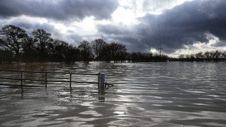
When does Flooding Occur
Flooding occurs when rivers burst their banks due to exceeding their capacity. The water then spills out onto the floodplain. The usual cause of flooding is heavy rainfall, and there are many factors that contribute to how likely a particular river is to flood.
The effects of flooding can be devastating. It can cause significant damage to property and possessions, disrupt communications and endanger the lives of people and animals. In February 2014, the Guardian reported that the clean up bill could hit £1 billion. Flooding can wipe out wildlife habitats or leave them polluted, and it can also cause soil erosion.
Why is it important to measure the condition of flood water?
Flood water testing allows you to learn how the chemical and biological quality of water bodies are affected. Such changes can have a detrimental effect on human health and the environment, as well as impacting the commercial and recreational uses of water bodies.
Which water quality parameters should be used in flood water monitoring?
There are a number of parameters that can be measured to ascertain the quality of flood water. These parameters are used together to gain a greater understanding of the water quality.
Turbidity indicates the quantity of suspended sediments in the water. Turbidity can affect the metabolism and spawning of aquatic species. Another parameter that directly affects aquatic life is dissolved oxygen, the levels of which are vital to maintain life under the water.
You may also measure the pH of the flood water. This is affected by chemicals such as nutrients and heavy metals in the water. Certain organisms adapt to live in a particular pH so just a small change could negatively impact aquatic life. Similarly, a minor change in salinity can have disastrous consequences.
Excessive rainfall can increase the amount of agricultural runoff entering streams, therefore increasing the levels of nitrates in the water. Too many nutrients can cause algal blooms that suffocate other life in the stream. Algal productivity can be indicated by measuring chlorophyll.
Another parameter to mention, and possibly one of the most obvious, would be water level. Measuring the rise and fall of the river over long periods of time will enable you to understand diurnal, seasonal and annual changes in water level. This could be used for modelling purposes.
Which Aquaread products can be used for flood water monitoring?
We design and manufacture a range of highly scientific water testing equipment to be used in the field. We have portable products that would be ideal for taking spot measurements across various locations, and products that are specifically designed for long term deployment and would be ideal for continuous water quality monitoring in one position.
The AP-2000 is a handheld, multiparameter probe that give you the ability to measure up to 13 parameters at once. The data is recorded in our Aquameter along with the GPS coordinates of the testing site so you can map your testing locations.
Both the AP-5000 and AP-7000 are suitable for unmanned, continuous water quality monitoring. The AP-7000 has a self-cleaning function so is perfect for long term deployment.
For monitoring water level, we have developed the LeveLine water level and temperature logger. This innovative device can be used for stream, lake and river water level management, or inside boreholes to monitor groundwater levels. We have also developed the LeveLine-EWS, which is both a continuous level monitor and early warning system for mitigating the potential damage that flooding can cause.
For any information about any of our products or to learn more about flood water monitoring, please get in touch.